


Satellite video of Sudan shows blood soaked ground, pointing to mass killings in Sudan
- M.Zubair

- Dec 18, 2025
- 4 min read
Updated: Dec 20, 2025
Introduction: The World Watches from Space
The satellite video of Sudan circulating across newsrooms and social platforms in late 2025 isn’t just another clip it’s a haunting window into what researchers and analysts are calling one of the most severe humanitarian catastrophes on Earth. Images and data captured by high resolution satellites show ground stained with blood, clusters of objects consistent with human remains, and mass burial activity in the Darfur region’s El Fasher city, painting a bleak picture of violence, civilian suffering, and potential war crimes.
In a conflict with restricted media access and communication blackouts, such satellite footage has become critical for understanding the reality on the ground.
The Conflict Context: Sudan’s Unfolding Crisis
Sudan’s war, which began in April 2023 between the paramilitary Rapid Support Forces (RSF) and the Sudanese Armed Forces (SAF), has escalated into a widespread humanitarian disaster. The RSF’s recent capture of El Fasher, a key city in North Darfur, marked a significant turning point.
What Led to Satellite Evidence Being Central?
Blocked Ground Access: Conflict zones such as El Fasher are controlled by forces that limit independent journalist entry, forcing global observers to rely on remote sensing.
Blackouts & Information Suppression: Communications interruptions and curfews make first hand reporting dangerous or impossible.
Satellite Visibility: Due to this restricted access, images and videos from orbit provide one of the few reliable means of documenting atrocity evidence.
Understanding the Satellite Video Evidence

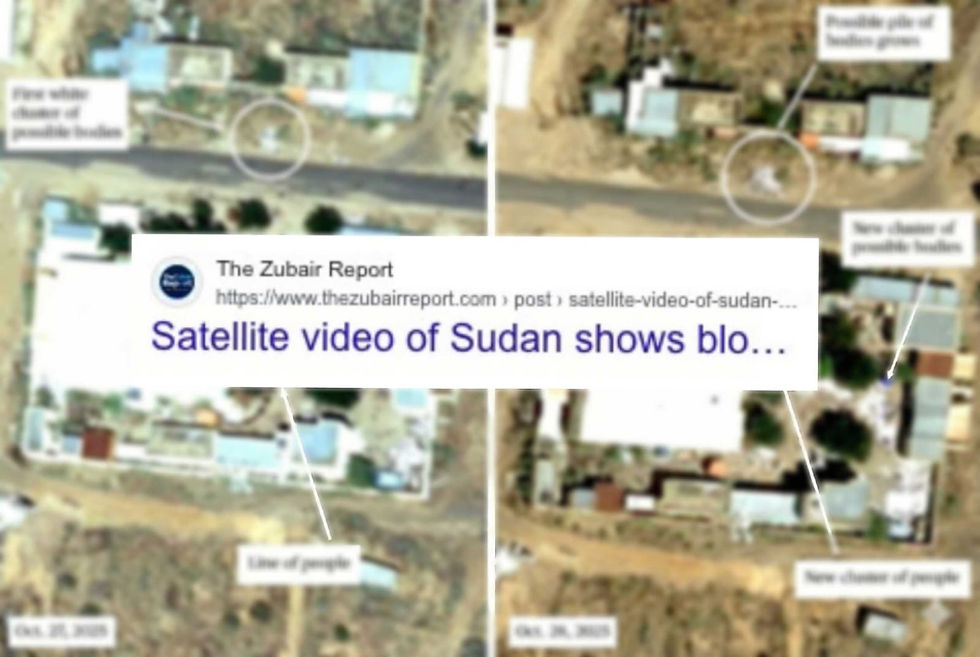
Satellite data doesn’t show video in the movie sense, but rather sequences of high resolution still imagery and infrared scans that can be stitched together into animated or time series visualizations.
Blood Stained Ground on Urban Roads:
Analysts at Yale University’s Humanitarian Research Lab reported areas where the soil or pavement appears discolored in patterns consistent with blood spread, correlating with documented reports of killings in narrow city streets.
Clusters of Bodies Consistent with Human Size:
The imagery identifies groups of objects approximately 1.3 to 2 meters in length dimensions similar to human bodies situated in places where violent encounters were reported.
Mass Burial Activity:
Later satellite captures show earth movement and trench like patterns near key civilian landmarks such as hospitals and mosques, consistent with rapid interment of multiple bodies.
Destruction & Burn Marks:
The imagery also shows signs of structural damage, charred vehicles, and repair activity consistent with sustained conflict and violence.
Divergence Between Verified and Viral Content
It’s important to distinguish between verified satellite evidence and misattributed images that have circulated online:
Some widely shared satellite screenshots turned out to depict livestock near waterholes, not massacre sites illustrating how easily imagery can be misinterpreted without expert analysis.
This distinction highlights the necessity of relying on verified analysis from trusted research institutions rather than viral social media posts.
Why Satellite Evidence Matters
Satellite imagery and video like time series data are crucial in conflicts where:
Ground reporting is impossible due to insecurity or restrictions
Governments or military actors deny access
Information is contested or weaponized
In such contexts, satellite evidence serves three major purposes:
1. Independent Verification
Unlike propaganda from warring factions, satellite data provides impartial perspectives from space. These images can be time stamped, dated, and independently analyzed, offering a check against misinformation.
2. Documenting Patterns of Atrocity
Such imagery helps human rights organizations, international courts, and humanitarian agencies detect patterns of violence, discern mass burial activity, and corroborate survivor testimonies.
3. Evidence for Accountability
High resolution satellite imagery plays an increasingly significant role in documenting potential war crimes and contributing to future legal proceedings, including potential cases at institutions such as the International Criminal Court (ICC).
Human Toll Behind the Imagery
Beyond the satellite shots lies an immense human tragedy. According to the United Nations and humanitarian agencies:
Tens of thousands of civilians have been killed since 2023
Millions are internally displaced or in need of urgent aid
Healthcare facilities, including hospitals, have been targeted repeatedly, exacerbating civilian suffering and death.
Eyewitness accounts and social media videos emerging from within El Fasher describe summary executions, forced displacements, and door to door violence creating what survivors describe as a slaughterhouse atmosphere.
The satellite video is not just an analytical tool; it reflects real human suffering happening daily.
International Response and Legal Implications
The satellite evidence has spurred international concern:
UK Sanctions: British authorities recently sanctioned RSF commanders for their alleged involvement in mass killings and systematic attacks on civilians.
UN Statements: Senior UN officials have condemned attacks on peacekeepers and civilian infrastructure, stressing potential violations of international humanitarian law.
Humanitarian Watchlists: Sudan remains at the top of global crisis lists due to displacement, famine risks, and escalating violence.
Despite this, there remains a significant gap between documented evidence and meaningful international action to halt ongoing violence or protect civilians.
What This Means for the World
The satellite video of Sudan is more than a visual; it is evidence. In an era of digital warfare and information conflict, space based monitoring offers an unprecedented tool to witness what might otherwise be concealed.
It also challenges global audiences to question verification methods, to look beyond sensational imagery, and to support independent analysis that respects both truth and dignity.
Conclusion: Seeing Satellite Video of Sudan from Space, Understanding Our Responsibility
Satellite images can’t feel the suffering on the ground, but they show the harsh reality we can’t ignore. From the blood-stained streets of El Fasher to suspected mass graves near hospitals and mosques, the satellite video of Sudan reveals what many have tried to hide. These images remind the world that even in the darkest moments of conflict, keeping track of the truth and seeking accountability is crucial.
What are your thoughts on how satellite images can help us understand conflicts like the one in Sudan? Share your opinion in the comments below. If you found this article helpful, please share it with others and subscribe for more clear, in depth insights on global events.


Comments